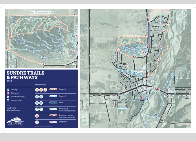
A new detailed guide highlighting Sundre’s network of trails and pathways is the most comprehensive to date, council heard recently.
“This map is the most complete map that we’ve ever had of our trail system, I would say the most accurate to date,” said Jon Allan, Sundre’s economic development officer, during the Feb. 19 meeting.
“This map will help us create a big picture perspective of where those trails are, and where we can keep certain unmaintained nature trails, where some might be allowed to go back to nature, and how we can actually move forward with connectivity, planning and budgeting for the future.”
Allan said the effort started last winter with Sundre Bike ’n Ski Club volunteers, who worked with the municipality’s community services department to compile a draft map.
“There were some deficiencies, so to speak, with it,” said Allan.
He offered to assist with the process to further develop a map that would include the entire town as well as be more reflective of the municipality’s destination branding.
“It’s essential to the community for marketing, for tourism development and for residents in general because we have such an amazing trails network in this community.”
In January 2018, the club was informed that the community services department would need until the fall to complete a comprehensive GPS mapping of the trails. An ad hoc trails working group led by community services met multiple times throughout the summer and into the fall, said Allan, who stepped in as the project’s lead following the departure of the department’s former manager Ian James.
“It’s important to note, that strategically speaking, getting the GPSing of the trails done — a proper, complete map of the trails — was essential to allow us to be able to see finally, with proper information, where our trails are trails, in order to be able to plan accordingly for connectivity into the future.”
The first phase of trail mapping with GPS included all of the sanctioned, municipally-owned trails and a small handful of nature trails that are not maintained by the town. The next phase, he said, will include GPS mapping of unsanctioned paths and commonly used nature trails.
Due to some conflicting GPS data that caused confusion regarding precise locations, Allan added that efforts were undertaken to physically walk the trails with volunteers using GPS devices to ensure the most accurate map possible.
The bike and ski club’s contributions have been important, and Allan said there are “not enough positive words I could share about that club.”
Operations department manager Jim Hall said there are “many projects going on to further the trails,” including an 800-metre extension in the southwest expected to be completed this year during the Phase 2 construction of Main Avenue West.
Facilitating the effort to develop and introduce new trails or connect existing ones is the new open trails and spaces plan that was adopted by council last year, said Hall.
Using the guidelines as well as engineering details and recommendations outlined in that document will help to design and incorporate projects into the capital plan without having to ask engineers, he said.
However, creating new trails is only a part of the equation, he added.
“We have to fix some of the areas.”
That entails preparing plans to plant willow trees, for example, along portions of the Red Deer River trails to stabilize the banks, some of which have been substantially eroded, resulting in the risk of someone falling into the river, he said.
“There’s some pretty bad erosion in areas, and we’ve got to treat those and get people back from those areas.”
Following the administrative staff’s report, Mayor Terry Leslie wondered whether there were plans to reopen the scar on Snake Hill, which he called an asset that offers a picturesque perspective for spectators for any number of events.
Hall said that kind of effort would be a standalone capital project and that details would need to be worked out and brought back to council for consideration. For the time being, it will remain off limits for the public’s safety, he said.
Coun. Cheri Funke praised the finished map, which she said will come in handy at the Visitor Information Centre, and wondered how much it cost.
Not including the printing, Allan said the design cost approximately $1,500, with expenses being split between the community services and economic development departments.
Coun. Richard Warnock wanted to know how the map would be distributed, to which Allan said trade shows would be one of the first stops.
“We get asked about that, and now we actually have something we can proudly show,” he said, adding the map will also be available in local establishments from the town office and information centre to key businesses such as hotels and tourism-related enterprises, with a digital version also available online.
“We promised we’d get trails on the app and that is finally being worked on.”
The mayor said in the mid-1990s, council set the groundwork to begin developing a trail system, and that the new map was the first time since then that so much work was put into updating that project.
Council unanimously carried Warnock’s motion to accept the report for information.


