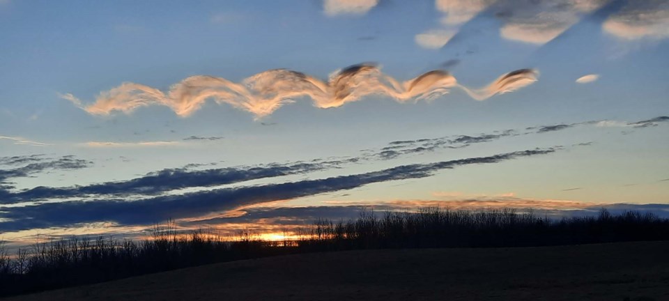
A rare helix-shaped cloud that appeared over Sturgeon County last week was likely caused by the same force that makes waves in the ocean, says Environment Canada.
Several St. Albert, Edmonton, and Sturgeon County residents reported sightings of an unusual wave-like or helix-shaped cloud in the skies between Morinville and Legal at about 4 p.m. Jan. 1.
Evan Jamison, the Gazette’s vice-president of manufacturing, said the cloud looked like either a double-helix or “a bunch of S’s in the sky all in a row.”
“I kind of looked at it a few times and said, ‘What the heck is that?’”
Sturgeon County resident and cloud enthusiast Carlynn Christoffersen said she saw the strange cloud while driving down Hwy. 2 between Legal and Vimy and about 4:10 p.m.
“I was just fascinated by it,” she said, adding that she regularly takes pictures of clouds.
“I’ve never seen one like it before.”
In an email, Telus World of Science Edmonton space sciences manager Frank Florian said he and his wife observed the cloud while travelling home from Barrhead. He said the formation appeared to be natural and long-lasting, as it was too large to be an aircraft contrail.
Judging from the description, this cloud was likely a Kelvin-Helmholtz or shear-gravity cloud, said Environment Canada meteorologist Natalie Hazel. (The World Meteorological Organization calls them “Fluctus” clouds.) These clouds are caused by Kelvin-Helmholtz instabilities that form when there is a velocity difference between two fluids of different densities, such as wind blowing over water.
“Typically you’re going to see these clouds when the bottom of the clouds are cooler, the air above is warmer, and the air above is moving more quickly than the air below,” Hazel said.
“It pushes over the top of the cloud and creates a rolling wave appearance.”
The UK’s Met Office describes these clouds as an “extremely rare phenomenon” that happens when air higher up is moving faster than air lower down. If a cloud is caught in between these air masses, the faster-moving upper layer scoops up the top of the cloud to a create a wave-like pattern. This same phenomenon (which is named after Hermann von Helmholtz and William Thompson/Lord Kelvin, who studied turbulent airflow) also causes wind to whip up waves in water.
Earthsky.org reports that these clouds show up most often on windy days near sunrise and sunset when the bottoms of clouds are cooler and the air above is warmer. Any airplanes in the vicinity of such clouds will likely experience turbulence.
While Kelvin-Helmholtz clouds probably aren’t particularly rare, Hazel said you do have to be in the right place and time to see them. And look quick — the conditions that cause these clouds don’t last very long.


